
A view down the Cumberland River

Once again we arrived in the rain. Is it following us or are we chasing it?
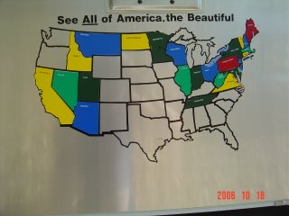
We added Tennessee to our map.

A view of the Cheasapeake Bay as we explore the area.

Looking across the James River before driving under it.

This is the entrance to the bridge/tunnel under the James River.
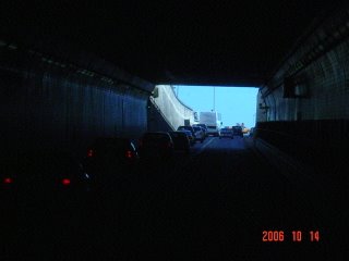
Exit from the tunnel under the James River. The bridge and Tunnel are about 5 1/2 miles with about 1 1/2 under water.

Virginia countryside. The road out of town.

Appears the road disappears -- but it is just very hilly and beautiful.
 A view down the Cumberland River
 Once again we arrived in the rain. Is it following us or are we chasing it?
 We added Tennessee to our map.
 A view of the Cheasapeake Bay as we explore the area.
 Looking across the James River before driving under it.
 This is the entrance to the bridge/tunnel under the James River.
 Exit from the tunnel under the James River. The bridge and Tunnel are about 5 1/2 miles with about 1 1/2 under water.
 Virginia countryside. The road out of town.
 Appears the road disappears -- but it is just very hilly and beautiful.
No comments:
Post a Comment